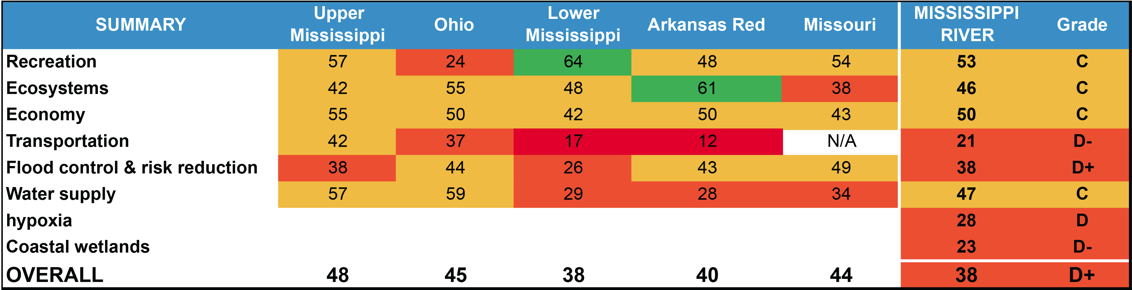
The Goals for the Mississippi River Watershed
America’s Watershed Initiative has identified six broad goals.America’s Watershed Initiative has identified six broad goals based on input from stakeholders and leaders throughout the watershed. These goals form a foundation for developing a shared vision for the future of the Mississippi River Watershed.
Explore the individual goals for the Watershed:
Water Quality & Ecosystems
2020 Overall Grade: D
2015 Grade: C
![]()
GOAL: Support and enhance healthy and productive ecosystems: Conserve, enhance and restore ecosystems within the Mississippi River Watershed to support natural habitats and the fish and wildlife resources that depend upon them.
Maintaining the health of ecosystems in the watershed contributes to achieving goals for water supply, flood protection, recreation, and the economy. High nutrient loads from wastewater, run-off, fertilizer, and livestock manure can create water treatment concerns and cause the growth of harmful algae that eventually reduces dissolved oxygen in the Gulf of Mexico. Annual nutrient loads at key locations in each basin have been steady or have gone up over the last five years, resulting in poor Water Quality scores in the 2020 Report Card.
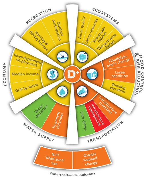
INDICATORS MEASURED:
- Water Quality: F
- Nutrient and sediment loading in each of the watershed’s basins
- Living Resources: Data not available
- Condition of aquatic animal communities living in the watershed’s ecosystem
- Streamside Habitat: Data not available
- Condition of stream and river habitat in the watershed’s ecosystem
- Freshwater Wetland: B-
- Percent change in wetland area in each basin
* Data from the US EPA Rivers and Streams Assessment to update scores for Living Resources and Streamside Habitat is not yet publicly available. When this data becomes available, an electronic update will be posted here.
Flood Control & Risk Management
2020 Overall Grade: D+
2015 Grade: D+
![]()
GOAL: Provide reliable flood protection and risk reduction through well managed and maintained infrastructure, including appropriate floodplain connections for water conveyance and ecosystem benefits, and management of surface and storm water runoff to better protect life, property and economies.
The challenge for flood control and risk reduction is to maintain existing measures that have proven effective—both structural and nonstructural—while at the same time finding new strategies that respond to a changing climate, rising sea levels, and coastal subsidence and erosion. Extreme flooding occurred in the watershed in five of the last 10 years, and the poor Flood Frequency scores in the report card reflect increasing trends in annual days of high-water flow. These patterns are becoming more extreme, with alternating periods of drought and high rainfall storms, complicating risk reduction.
INDICATORS MEASURED:
- Floodplain Population: C+
- Change in the number of people most at risk of flooding compared with the change in number of people living in a basin overall
- Levee Condition: D
- Status of levees inspected by the U.S. Army Corps of Engineers
- Flood Frequency: D
- The frequency of flooding in each of the basins as measured by the number of days that exceed flood discharge thresholds
Transportation
2020 Overall Grade: C
2015 Grade: D-
![]()
GOAL: Serve as the nation’s most valuable river transportation corridor: Provide for safe, efficient and dependable commercial navigation within the Mississippi River Watershed to ensure a competitive advantage for our goods in global markets.
The Mississippi River and its tributaries serve as the nation’s most valuable river transportation corridor, providing safe, secure, well-maintained, and future-oriented inland infrastructure that is integrated with rail and highway transport to support cost-effective movement of goods and materials. Transportation scores improved from 2015, partly due to lock delay and infrastructure funding improvements. However, upgrades, regular maintenance, and capacity expansion are urgently needed to accommodate increasing demands on transportation and frequency of emergency situations such as flooding and natural disasters.
INDICATORS MEASURED:
- Infrastructure Condition: C
- Condition of critical infrastructure at locks and dams
- Infrastructure Maintenance: C-
- The adequacy of funding for operations and maintenance of critical navigation infrastructure
- Lock Delays: B-
- The average amount of time that locks in a basin were unavailable, weighted by the amount of traffic passing through the lock
Water Supply
2020 Overall Grade: C
2015 Grade: C-
![]()
GOAL: Maintain supply of abundant clean water: Ensure the quality and quantity of water in the Mississippi River Basin is adequate to support the economic, social and environmental functions that are dependent on it.
People value clean surface and ground water supplies for multiple uses, including domestic uses, recreation, agricultural, and industrial water uses. But these critical resources are threatened; drinking water supplies are frequently affected by high nitrogen concentrations and groundwater from deep aquifers is being extracted much faster than it is refilled. It is critical to improve the capacity of the Mississippi River Watershed to provide water that is of sufficient quality and quantity for the range of uses, and to support the heath of ecosystems and the services they provide.
INDICATORS MEASURED:
- Water Depletion: B-
- The available amount of surface water in a region compared with the net amount of water used by people
- Treatment Violations: D+
- Data on violations by community water treatment systems reported to the U.S. Environmental Protection Agency
Economy
2020 Overall Grade: C
2015 Grade: C
![]()
GOAL: Support local, state and national economies: Sustain a water use system to efficiently and effectively support agricultural, industrial and energy productivity.
The diverse economy of the Mississippi River Watershed continues to drive the national and global economies. Employment has remained relatively high compared to other areas in the US, owing in part to the regions’ incredible economic diversity, which includes agriculture, energy, industry, transportation, and recreation, among many other sectors. However, as important as the Mississippi River Watershed is to the economy, national investment to support the watershed has not kept pace, and the total amount of water available for use is limited, with diminished water quality adding to difficulties.
INDICATORS MEASURED:
- River-Dependent Employment: C+
- The number of people employed in river-dependent sectors (farming, fishing, & forestry; production; transportation and material moving) compared to the national average employment in these industries
- Per Capita Income: C
- The median per capita income per county compared to the median for all Mississippi River Watershed counties
- GDP by Sector: C
- Gross domestic product (GDP) for selected industries compared to the national average GDP in these industries
Recreation
2020 Overall Grade: C+
2015 Grade: C
![]()
GOAL: Provide world-class recreation opportunities: Enrich the quality of life for people and recreation-based economies by maintaining and enhancing riverine, lake and wetland-associated recreation within the basin.
Access to recreational areas and other opportunities for outdoor activity enriches people’s lives and benefits the economy. Every year in all seasons, millions of people fish, boat, hike, watch birds, and visit cultural sites along the rivers of the Mississippi River Watershed. These activities support a multi-billion-dollar recreational economy. Outdoor recreation area use and park visitation have increased dramatically in 2020 as a result of the COVID-19 pandemic. But recreational areas and opportunities are under pressure by competing uses and ecological stresses like invasive species.
INDICATORS MEASURED:
- Outdoor Participation: C
- Number of participants in hunting, fishing, and birding and visitors to national parks within each basin compared with their 20-year historical ranges
- Hunting and Fishing Licenses: B-
- The three-year average of hunting and fishing license sales compared with 20-year historical license sales
Explore the Report Card by Goal

The Six Goals
Click on any goal to explore further.
Coastal Wetlands
 The Report Card includes watershed-scale data pertaining to coastal wetlands.
Coastal Hypoxia
 The Report Card includes watershed-scale data pertaining to hypoxia in the Gulf of Mexico.
The chart at right provides an overview of all grades provided in the Report Card.