Upper Mississippi River
The Upper Mississippi River Basin is home to approximately 30 million people with three major cities and many smaller cities and towns. Forests and lakes in the northern headwaters and highly productive agricultural land to the south dominate the landscape. An extensive series of locks and dams regulate water levels on the Mississippi River south of Minneapolis and St. Paul, Minnesota, and on the Illinois River, providing navigation on the Mississippi River and to the Great Lakes through Chicago, Illinois. Popular recreation areas support extensive boating, swimming, hunting and fishing, and include a 260-mile-long National Wildlife Refuge that covers parts of four states.
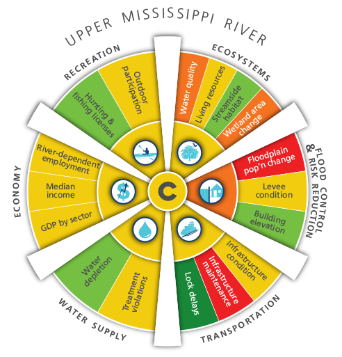
The Upper Mississippi River Basin received an average of a C grade for the six goals. This basin had relatively few navigation lock shutdowns, a high percentage of communities that have building elevation requirements as a non-structural flood protection measure, good quality streamside habitat, relatively high hunting and fishing license sales, and relatively high water availability compared to the national average. However, the condition and maintenance of the transportation infrastructure within the basin is poor, it has seen a substantial increase in population within floodplains (relative to the population change in the basin), its water quality ranks poorly, and there is a high rate of wetlands loss.
The Upper Mississippi River Basin is located on the “wet side” of the 100th meridian, which marks a shift in rainfall pattern from the wetter eastern portions of the basins and the drier western portions. The Upper Mississippi therefore has relatively low water stress compared to other areas. Intense agricultural use and large population centers, including Chicago and Minneapolis, may contribute to poor water quality results and wetland losses.
Related Links
Grades Explained by Goal
Ecosystems
The Upper Mississippi Basin received a grade of C- for Ecosystems. The Living Resources indicator received a C-. The Streamside Habitat indicator received a B, one of only 2 basins with this highest grade. The Water Quality indicator in the Upper Mississippi received a D+. The wetland area change indicator received a D.
Flood Control & Risk Reduction
The Upper Mississippi Basin received a grade of D+ for Flood Control & Risk Reduction. The Floodplain Population Change indicator in the Upper Mississippi received a failing grade and the Levee Condition indicator received a C grade. The Building Elevation indicator received a B- grade, among the best grades in the watershed.
Transportation
The Upper Mississippi Basin received a grade for D Transportation. The Infrastructure Condition indicator received a D-. The Infrastructure Maintenance indicator received an F for the entire watershed. The Lock Delays indicator in the Upper Mississippi received an A grade, the highest in the watershed.
Water Supply
The Upper Mississippi Basin received a grade of C+ for Water Supply. The Treatment Violations indicator in the Upper Mississippi received a C grade, and this was the highest of all basins in the entire watershed. The Water Depletion indicator received the highest grade of B, a grade this high was also seen in the Ohio and Tennessee River Basin.
Economy
The Upper Mississippi Basin received a grade C+ for economy. The River Dependent Employment indicator in the Upper Mississippi received a C+ grade. The Median Income indicator received a C grade. The GDP by Sector indicator received a C grade.
Recreation
The Upper Mississippi Basin received a grade of C+ for Recreation. The Outdoor Participation indicator received a C- and the Hunting and Fishing Licenses indicator received a B.
The AWI Report Card was developed over two years with significant amount of information and feedback from hundreds of experts and stakeholders throughout the watershed and nation. View a comprehensive Report Card technical paper that includes data sources, calculations and analysis.


