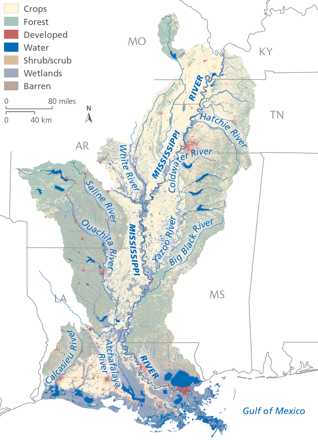
Lower Mississippi River
The Lower Mississippi River Basin is used extensively for transportation, made possible by a natural supply of abundant water from upstream and the comprehensive Mississippi River and Tributaries Project. This two-way transportation system—with its levees, floodways, channel improvements and tributary basin improvements—links the cities, factories and farms of the American heartland to world markets. The facilities along this stretch of river comprise the largest port system in the world in terms of tonnage moved. The coastal wetlands here support recreational activities, agriculture and a seafood industry valued at billions of dollars per year.
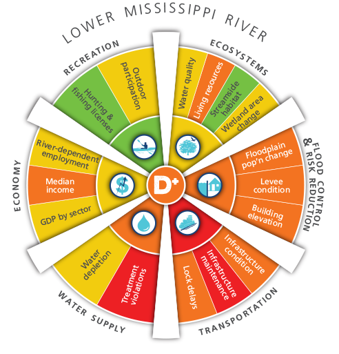
The Lower Mississippi River Basin received an average score of D+ in the report card for the six goals. The basin had high marks for recreation from hunting and fishing license sales and relatively good streamside habitat. The low overall score is driven by poor condition of the communities of fish and organisms living in the river and stream bottoms, substantially lower median income, lock delays approaching the worst-performing year, poor infrastructure condition and maintenance, an increase in the number of people moving into the floodplain relative to overall population change, poor levee condition, low numbers of communities with building elevation requirements, and nearly 5 percent of water supply systems reporting treatment violations.
The Lower Mississippi River receives all of the water that flows down from the other basins as well as the riverine transportation of imports and exports that make up a large component of the national economy. The poor performance in lock delays and inland infrastructure condition and maintenance paints a challenging picture for future transportation system failures, with potentially devastating national economic consequences. As the bottom of the “funnel,” the basin also feels the effects of flooding that occur anywhere in the Mississippi River Watershed. The flood control and risk reduction issues that are reported in the scores represent relative risk; however, despite the low scores, the flood control system performed exceedingly well during the record floods of 2011 as no lives were lost and there was minimal property damages.
The coastal wetlands in the Lower Mississippi River continue to decline although increasing efforts to slow the loss–including water diversions and beneficial use of materials dredged from the shipping channel to restore wetlands–are having a positive impact. Coastal waters in the Gulf of Mexico are threatened by a large hypoxic zone that depletes oxygen from the water that forms annually as the result of excess nutrient runoff from the river.
Related Links

Grades Explained by Goal
Ecosystems
The Lower Mississippi River Basin received a grade of C for Ecosystems. The Living Resources indicator received a D and the Streamside Habitat indicator received a B grade, one of 2 basins with this highest grade. The Water Quality indicator received a C and the wetland area change indicator received a C-.
Flood Control & Risk Reduction
The Lower Mississippi Basin received a grade of D for Flood Control & Risk Reduction. The Floodplain Population Change indicator in the Lower Mississippi received a D grade. The Levee Condition indicator received a D grade and the Building Elevation indicator received a D- grade.
Transportation
The Lower Mississippi Basin received a Failing grade for Transportation. The Infrastructure Condition indicator received an F. The Infrastructure Maintenance indicator received an F for the entire watershed. The Lock Delays indicator received a D grade.
Water Supply
The Lower Mississippi Basin received a grade of D for Water Supply. The Treatment Violations indicator in the Lower Mississippi received an F grade, one of two basins with failing grades. The Water Depletion indicator received a C+ grade.
Economy
The Lower Mississippi Basin received an overall grade of C- for Economy. The River Dependent Employment indicator in the Lower Mississippi received a C grade while the Median Income indicator received a D grade. The GDP by sector indicator received a C grade.
Recreation
The Lower Mississippi Basin received a grade of B for Recreation, receiving the highest score in the watershed for this goal. The Outdoor Participation indicator received a C while the Hunting and Fishing Licenses indicator received a B, which was the highest of all basin scores for this indicator.
The AWI Report Card was developed over two years with significant amount of information and feedback from hundreds of experts and stakeholders throughout the watershed and nation. View a comprehensive Report Card technical paper that includes data sources, calculations and analysis.